
Holm Akhdar Reports Unit
ADEN, Feb 16, 2025 (Holm Akhdar) – The Republic of Yemen has a long history of seismic and volcanic activity related to its location in the southwestern Arabian Peninsula and eastern Africa (Somalia, Djibouti, and Eritrea), part of the active Arabian tectonic plate. (Alrubaidi, et al., 2021) Earthquake is one of the most devastating natural hazards, causing enormous loss of life and property throughout history. Destruction is caused by the collapse of buildings and compounded by landslides, floods, tsunamis, and fires arising due to earthquakes. (Alrubaidi, et al., 2021)
Yemen is located along a permanent seismic fault line and experiences almost daily seismic tremors, but the magnitude of these tremors is below the level of human perception. (GSMRA, 2023) The comprehensive national report on seismic activity in the country indicates that Yemen’s geographical location overlooks two prominent of the tectonic plates to crack the Earth’s crust. The first plate lies in the Red Sea, while the second lies in the Gulf of Aden within the Arabian Sea. (NIC Yemen, 2009) Consequently, Yemen faces the imminent risk of earthquakes should there be a significant escalation of gases activity in the Red and Arabian Seas.
The collision zones between the Arabian and Eurasian plates are the principal cause of earthquakes in Yemen. Seismic history of Yemen indicates the occurrence of major earthquakes with 20 to 30 years recurrence periods. (World Bank, 2010)
“ Dhamar area has the greatest seismic hazard in Yemen in accordance with seismic hazard maps and the high seismic activity inside the region.” (Alrubaidi, et al., 2021)
Over the past decades, Yemen has experienced devastating seismic events. The 1982 Dhamar earthquake, one of the largest destructive seismic events in southern Arabia, resulted in over 2,500 fatalities, 1,500 injuries, and the displacement of 500,000 individuals. Approximately 300 rural villages were destroyed, and over 12,000 homes and various facilities and services incurred massive destruction. (World Bank, 2010)
Similarly, the 1941 earthquake in Saada, one of the most devastating earthquakes in Yemen’s modern history, claimed approximately 1,200 lives and caused the destruction of around 1,700 homes. The tremors continued for nearly three months. Additionally, the 1991 earthquake, in Al-Udain district in Ibb governorate resulted in significant devastation in Jabal Bahri and Hazm Al-Udain district, leading to 12 fatalities, over 30 injuries, and damage to 7,150 houses, with 1,578 of them being completely destroyed. (NIC Yemen, 2009)
In 1991, Yemen established the National Seismological Observatory Center (NSOC), later in 2006, it was renamed the Center for Monitoring and Studying Earthquakes. (NIC, 2006) Located in Mount Haran, Dhamar governorate, south of Sana’a, it stands among the oldest seismic centers in the region. Equipped with 18 high-sensitivity (MARS-88) substations and a digital network for monitoring strong ground movements (SSA-2) comprising 17 digital seismic monitoring and reporting stations distributed across the governorates. This center diligently monitored and archived seismic data. It operated an integrated system for comprehensive management, monitoring, and tracking of earthquake and volcanic activities in the country, in addition to conducting risk assessments in various regions of the country and developing plans and preventive measures. Regrettably, due to the outbreak of war in the country, the Earthquake Monitoring Center in Dhamar was completely destroyed on May 21, 2015, by aerial bombardment, leading to the irrevocable loss of all seismic data.
The destruction of the Earthquake Monitoring Centre in Yemen has resulted in the loss of the country’s capability to effectively monitor and record seismic tremors. The disruption of seismic networks since 2015 has severely impeded access to seismic code, hindering the availability of comprehensive seismic records. Consequently, the center’s staff has been unable to record minor earthquakes occurring in the country. (Holm Akhdar, 2023)
Currently, the internationally recognized Yemeni government has reactivated the earthquake monitoring center, and the Geological Survey Authority in the interim capital, Aden, has established the National Earthquake Monitoring Center to monitor seismic activity based on data obtained from international stations, with which it has a cooperative relationship in the field of seismic monitoring and studies. However, this center still needs support and the reconstruction of seismic monitoring stations destroyed by the war.
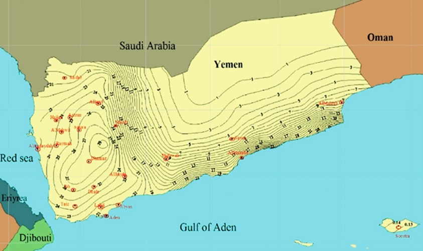
According to a local study conducted in 2021, Dhamar area has the greatest seismic hazard in Yemen in accordance with seismic hazard maps and the high seismic activity inside the region. (Alrubaidi, et al., 2021) The second active area is in Sana’a region and its surrounding northern regions. In the southern part of Yemen, moderate seismic activity has been detected near Aden. Some areas have experienced relatively similar seismic activity to their surroundings, such as Yemen’s west and south coasts, Abyan, Taiz, Al-Dhale, and Lahij regions. Acceleration values throughout the Eastern Desert Shabwah, Sayun, and Al-Mahra are characterized by extremely low seismic activity, (Alrubaidi, et al., 2021) as shown in map (1).
Mass movements (rockslides/landslides) in Yemen are not uncommon. An illustrative incident took place on December 28, 2005, in Al-Dhafeer village, Bani Matar district in Sana’a. This rockslide had a tragic loss of over 90 lives, the destruction of approximately 20 homes, and the displacement of hundreds of residents. The 2010 National Contingency Risk Assessment by the World Bank notes that most of Yemen’s populations are located at the foothills of mountains or under cliffs and are therefore vulnerable to rockslides and landslides. These disasters can be attributed to a combination of natural and man-made factors. Natural factors include geological fragility, tectonic activity, climate change, as well as extreme variations in temperature and precipitation. (World Bank, 2010)
References:
Alrubaidi, M., Alhaddad, M., Al-Safi, S., Alhammadi, S., Yahya, A., & Abadel, A. (2021). Assessment of seismic hazards in Yemen. Retrieved from Heliyon journal: https://www.cell.com/action/showPdf?pii=S2405-8440%2821%2902623-2
Holm Akhdar. (2023). Report about the Center for Monitoring and Study of Earthquakes, Sep 13, 2023. Retrieved from Holm Akhdar Platform: https://holmakhdar.org/resources/studies/7374/
GSMRA. (2023). Geological experts resolve the controversy over the threat of the Turkish earthquake to Yemen. Retrieved from Geological Survey and Mineral Resources Authority, Yemen. Sept 10, 2023: https://www.gsmr-aden.org/site/3013/
NIC. (2006). Republican Decree No. (65) of 2006, establishing the Center for Monitoring and Study of Earthquakes. Retrieved from National Information Center, Yemen: http://yemen-nic.info/news/detail.php?ID=9275&print=Y
NIC Yemen. (2009). National Report about Seismic Activity in Yemen. Sana’a: National Information Center.
World Bank. (2010, Sep). Yemen National Probabilistic Risk Assessment: Historical Hazard Data Review, Analysis and Data Quality Assessment. Retrieved from the World Bank: https://www.geonode-gfdrrlab.org/documents/681/link
